 polyGIS
Overview
polyGIS is a Chrome extension developed by mihalcea.bogdan.daniel.
According to the data from Chrome web store, current version of polyGIS is 0.0.1, updated on 2021-09-14.
313 users have installed this extension.
5 users have rated this extension with an average rating of .
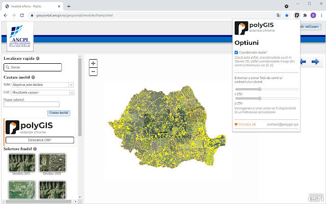
Extension for downloading DXF files of Romanian Cadasters
This extension works together with the Romanian website
https://geoportal.ancpi.ro/geoportal/imobile/Harta.html.
The mentioned website stores and displays public information about the Romanian National Lands and Cadasters in the Stereo-70 national reference system.
This extension allows users to download in a vectorial format (DXF) of a searched cadaster, facilitating higher precision in the measurement of terrains in CAD software.
This extension is practical for architects when the parcel limits are not available to them. Also, this is handy for investors seeking terrains suitable for their needs.
Note:
The information provided by the polyGIS extension is unenforced by Romanian laws. All the information supplied is only for consulting reasons. For legally enforced documents, please refer to the nearest city hall or ANCPI, following procedures described by the Romanian laws.
The developer of this extension is not responsible for any damage created by the misuse of this application.
ANCPI or the Romanian State has the legal right to restrict access to this extension by referring to its developer.
polyGIS Alternatives
| Name | Category | Rating | Rating Count | Installs |
|---|---|---|---|---|
 AutoCAD Viewer for Google Drive™
|
Productivity | (213) | 20,000+ | |
 DXF Viewer
|
Productivity | (517) | 100,000+ | |
 Jiga 3D CAD Viewer for Gmail
|
Productivity | (16) | 2,000+ | |
 Jira Followers Groups
|
Productivity | (1) | 29 | |
 Salesforce Unlimited Login
|
Productivity | (0) | 31 | |
 Countdown Timer
|
Productivity | (1) | 14 | |
 SENĆOŦEN Keyboard
|
Accessibility | (0) | 56 | |
 Emoji Inserter
|
Fun | (1) | 29 | |
 7 Words
|
Fun | (0) | 16 | |
 Virtual School Lingo Bingo
|
Fun | (6) | 38 | |
 Rubrika
|
Social & Communication | (96) | 1,000+ | |
 Word Search Pictures
|
Fun | (0) | 0 | |
 QR it!
|
Productivity | (1) | 18 | |
 Pricy
Pricy
|
Shopping | (136) | 100,000+ | |
 National to Reptile
|
Fun | (2) | 12 | |
 ArchDaily New Tab
|
Productivity | (297) | 40,000+ | |
 NoKey
NoKey
|
Productivity | (0) | 16 | |
 Point
Point
|
Shopping | (0) | 57 | |
 Mechanical Rights
|
Social & Communication | (0) | 5 | |
 Running Redmine
|
Productivity | (0) | 11 | |
 Simple Letter Counter
|
Productivity | (1) | 28 | |
 Simple Calculator
|
Productivity | (14) | 14 | |
 New York Times Puzzle Solver
|
Fun | (0) | 39 | |
 Arcanus 55 On-Screen Virtual Keyboard
|
Productivity | (2) | 7 |
Latest Reviews
See More|
2022-01-13
Super utila! Merge foarte bine si multumesc creatorului! Pe langa descarcarea zonei extinse pe care o astept cu desavarsire ar mai fi o idee buna sa poata descarca si geometriile cladirilor. Multumesc inca odata! Spor! |
|
2021-11-24
extensia e utila, pacat ca e blocata de cei de la ANCPI. poate gasiti o cale sa o reactiveze. |
|
2021-11-23
foarte util plugin-ul, dar recent cred ca a fost blocat de cei de la ancpi, odata cu noul update la sistemul lor. |
|
2021-09-15
Descarca conturul la scara, e ok insa nu in Stereo70. Se lipeste pe origine 0.00 / 0.00. Daca o faceti functionala dau 5 stele. Spor |
|
2022-01-13
Super utila! Merge foarte bine si multumesc creatorului! Pe langa descarcarea zonei extinse pe care o astept cu desavarsire ar mai fi o idee buna sa poata descarca si geometriile cladirilor. Multumesc inca odata! Spor! |